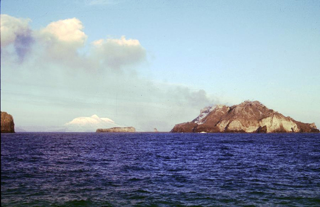
McDonald Island

McDonald Islands

Complex volcano · Australia · 263m

Three small, low islands on the Kerguelen Plateau form the McDonald Islands. The largest island, McDonald, is only 1 km2 in area and around 200 m high. This April 1997 photo shows a plume at Samarang Hill (right). The Island is composed of a layered tuff plateau cut by dikes and lava domes. A possible nearby active submarine center was inferred from pumice that washed up on Heard Island in 1992. The snow-capped peak in the background is Heard volcano, 44 km to the E.
Three small, low islands on the Kerguelen Plateau form the McDonald Islands. The largest island, McDonald, is only 1 km2 in area and around 200 m high. This April 1997 photo shows a plume at Samarang Hill (right). The Island is composed of a layered tuff plateau cut by dikes and lava domes. A possible nearby active submarine center was inferred from pumice that washed up on Heard Island in 1992. The snow-capped peak in the background is Heard volcano, 44 km to the E. · Photo: Copyrighted photo by Richard Williams, 1997 (Australian Antarctic Div., published in Global Volcanism Network Bulletin).
Type
Complex volcano
Country
Australia
Region
Somalian-Antarctic Volcanic Regions / Kerguelen Hotspot Volcano Group
Elevation
263m
Coordinates
-53.039, 72.595
Last eruption
2005
Tectonic setting
Intraplate / Oceanic crust (< 15 km)
Landform
Composite
Major rock type
Phonolite
Geological summary

The McDonald Islands are located on the Kerguelen Plateau about 75 km W of Heard Island. The largest island, McDonald, is composed of a layered phonolitic tuff plateau cut by phonolitic dikes and lava domes. A possible nearby active submarine center was inferred from phonolitic pumice that washed up on Heard Island in 1992. Volcanic plumes were observed in December 1996 and January 1997 from McDonald Island. During March 1997 the crew of a vessel that sailed near the island noted vigorous steaming from a vent on the N side of the island along with possible pyroclastic deposits and lava flows. A satellite image taken in November 2001 showed the island to have more than doubled in area since previous reported observations in November 2000.

From Wikipedia

The McDonald Islands are an uninhabited archipelago in the southern Indian Ocean in the vicinity of Heard Island. Together with Heard Island, they make up the Australian external territory of Heard Island and McDonald Islands. The McDonald Islands are the emergent peaks of submarine volcanoes and are Australian external territory. Prior to 1992, there had not been an eruption in the previous 75,000 years.

Wikipedia · CC BY-SA · Read full article

Eruption history

Summary (VEI over time)
Click a bar to see individual eruptions
1992~1993 · 1 eruptions · max VEI 01996~1997 · 1 eruptions · max VEI 12000~2001 · 1 eruptions · max VEI 12004~2005 · 2 eruptions · max VEI 119921995199920012004

Detailed timeline

  1. 2005VEI 0Observed
    2005-07-12 – Ongoing
  2. 2004VEI 1Geological estimate
    2004-11-14 – 2004-11-14
  3. 2001VEI 1Observed
    2001-05-03 – Ongoing
  4. 1996VEI 1Observed
    1996-12-16 – 1997-02-10
    Northern part of McDonald Island
  5. 1992VEI 0Observed
    1992-12-16 – Ongoing
    Submarine vent near McDonald Islands

External links

⚠ For reference only. Not for emergency response.