Risco Plateado
Stratovolcano · Argentina · 4999m
- Type
- Stratovolcano
- Country
- Argentina
- Region
- South America / Southern Andean Volcanic Arc
- Elevation
- 4999m
- Coordinates
- -34.917, -69.981
- Last eruption
- Unknown
- Tectonic setting
- Subduction zone / Continental crust (> 25 km)
- Landform
- Composite
- Major rock type
- Andesite / Basaltic Andesite
Geological summary
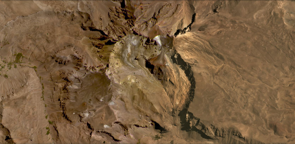
The Risco Plateado volcanic complex lies about 10 km S of the Caldera del Atuel and consists of a stratovolcano cut by a 4-km-wide caldera. Two eruptive centers are located on the SW and NE caldera rims along a NE-trending fracture that extends to a cone on the lower NE flank about 8 km from the caldera. Dominantly basaltic andesite lava flows overlie initial dacitic flows. Very youthful-looking basaltic lava flows from the NE-flank center extend NE to the Río del Atuel. Lava flows from the SW-rim center extend westward beyond the flanks of the complex and those from the NE-rim center flow into the caldera and down its NE flank.
From Wikipedia
Risco Plateado is a stratovolcano in Argentina, with an elevation of 4,999 metres (16,401 ft) above sea level. With a prominence of 1,602 metres (5,256 ft), it is one of the many ultra prominent peaks in the Andes. The equilibrium line altitude of the volcano lies at an altitude of 3,800 metres (12,500 ft).
Wikipedia · CC BY-SA · Read full article →
Eruption history
Detailed timeline
No eruption records available.
External links
⚠ For reference only. Not for emergency response.