Saltar al contenido principal

St. Andrew Strait

Volcán complejo · Papua New Guinea · 270 m

The St. Andrew Strait volcano is located in the Admiralty Islands north of Papua New Guinea. The volcanic complex consists of a series of overlapping Quaternary cones formed by rhyolitic lava flows and pyroclastic deposits on Lou and Tuluman Islands. Volcanism is aligned along a curved arc, extending through the 12-km-long Lou Island. Tuluman Island, seen here from the SW with Lou Island 1.5 km away at the upper left, was formed during a 1953-57 eruption.
The St. Andrew Strait volcano is located in the Admiralty Islands north of Papua New Guinea. The volcanic complex consists of a series of overlapping Quaternary cones formed by rhyolitic lava flows and pyroclastic deposits on Lou and Tuluman Islands. Volcanism is aligned along a curved arc, extending through the 12-km-long Lou Island. Tuluman Island, seen here from the SW with Lou Island 1.5 km away at the upper left, was formed during a 1953-57 eruption. · Foto: Photo by Wally Johnson, 1964 (Australia Bureau of Mineral Resources).
Tipo
Volcán complejo
País
Papua New Guinea
Región
Southwestern Pacific Volcanic Regions / Bismarck Sea Volcanic Province
Altitud
270 m
Coordenadas
-2.380, 147.350
Última erupción
1957
Contexto tectónico
Subduction zone / Oceanic crust (< 15 km)
Forma volcánica
Composite
Roca principal
Rhyolite
Resumen geológico

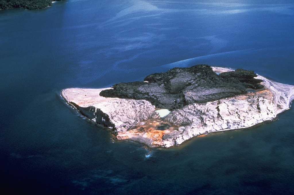
The St. Andrew Strait volcano, located in the Admiralty Islands north of Papua New Guinea, consists of a series of overlapping Quaternary cones formed by rhyolitic lava flows and pyroclastic materials on Lou and Tuluman Islands. Volcanism is aligned on a curved arc extending through the 12-km-long Lou Island. The Tuluman Islands, 1.5 km S of Lou Island, were formed during a 1953-1957 eruption. Pam Lin and Pam Mandian Islands farther to the SE along the same arc contain fresh rhyolitic obsidian similar to that found on Tuluman.

Resumen de Wikipedia

Resumen en inglés

St. Andrew Strait is a compound volcano in Papua New Guinea that has had eruptions in historical times. The volcano is not linked to any tectonic plates, the volcano is also in an area of very few earthquakes, suggesting that St. Andrew Strait is an Intraplate volcano. It consists of a group of Quaternary volcanic cones that are mainly rhyolitic in composition. The volcanism is curved, suggesting that the volcano has an ancient caldera. The centre of the volcano is Lou Island. Lou island last erupted in 240 BC and 340 AD, both eruptions came from the Bendal volcano. Lou island is the largest eruptive centre of the volcano, with 6 volcanic vents. The Pam Islands also contain fresh deposits. Historic eruptions have come from the Tuluman Islands.

Wikipedia · CC BY-SA · Leer artículo completo

Historial de erupciones

Resumen (VEI en el tiempo)
Haga clic en una barra para ver erupciones individuales
240 BCE~41 BCE · 1 erupciones · VEI máx. ?159~358 · 1 erupciones · VEI máx. ?1754~1953 · 3 erupciones · VEI máx. 2240 BCE35875713551754

Línea de tiempo detallada

  1. 1953VEI 2Observado
    1953-06-27 – 1957-01-28
    Tuluman
  2. 1931VEI 0Estimación geológica
    1931 – En curso
    Tuluman (?)
  3. 1883VEI 2Observado
    1883-03-28 – En curso
    Tuluman
  4. 350VEI ?Estimación geológica
    350 – En curso
    Lou Island (Bedal volcano)
  5. 240 a. C. (±100 años)VEI ?Estimación geológica
    BCE 240 – En curso
    Lou Island (Bedal volcano)

Enlaces externos

⚠ Solo como referencia. No apto para respuesta ante emergencias.