Gunung Serua
Serua
Stratovolkan · Indonesia · 608 m
- Tipe
- Stratovolkan
- Negara
- Indonesia
- Wilayah
- Sunda & Banda / Inner Banda Volcanic Arc
- Ketinggian
- 608 m
- Koordinat
- -6.312, 130.017
- Letusan terakhir
- 1921
- Kondisi tektonik
- Subduction zone / Oceanic crust (< 15 km)
- Bentuk lahan
- Composite
- Batuan utama
- Andesite / Basaltic Andesite
Ringkasan geologi
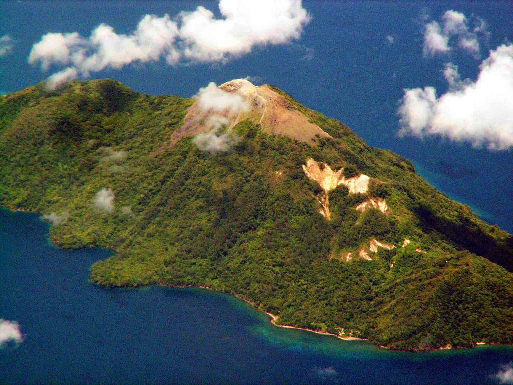
The 2 x 4 km island of Serua is the emergent summit of a volcano rising 3,600 m above the Banda Sea floor. A truncated central cone surrounded by an old crater wall is capped by the Gunung Wuarlapna lava dome. This andesitic volcano, also known as Legatala, lies near the center of the Banda arc and has had many eruptions recorded since the 17th century.
Ringkasan Wikipedia
Gunung Serua adalah sebuah gunung berapi yang berada di Laut Banda, Indonesia. Letusan terakhirnya terjadi pada tahun 1921. Pulau Serua adalah sebuah Pulau vulkanik yang terletak di Laut Banda, Indonesia. Secara administratif pulau ini merupakan bagian dari Kabupaten Maluku Tengah, Provinsi Maluku. Desa utama di pulau ini adalah Desa Jerili. Penduduk di pulau ini sekarang dipindahkan ke Pulau Seram karena aktivitas vulkanik gunung ini.
Wikipedia · CC BY-SA · Baca artikel lengkap →
Riwayat letusan
Garis waktu rinci
- 1921VEI 2Teramati1921-09-18 – BerlangsungSummit and south flank
- 1919VEI 2Teramati1919-11-16 – Berlangsung
- 1859VEI 2Teramati1859-07-02 – Berlangsung
- 1858VEI 2Teramati1858-07-02 – Berlangsung
- 1846VEI 2Teramati1846-09-16 – Berlangsung
- 1845VEI 2Perkiraan geologi1845-07-02 – Berlangsung
- 1844VEI 2Teramati1844-08-16 – 1844-09-16
- 1694VEI 3Teramati1694 – Berlangsung
- 1693VEI 4Teramati1693-06-04 – 1693-07
- 1692VEI ?Perkiraan geologi1692-06-04 – Berlangsung
- 1687VEI 3Teramati1687-06-15 – Berlangsung
- 1683VEI 3Teramati1683 – Berlangsung
Tautan eksternal
⚠ Untuk referensi saja. Bukan untuk tanggap darurat.