Rumble II West Seamount
Rumble II West
Stratovulcano · New Zealand · 1200 m (sottomarino)
- Tipo
- Stratovulcano
- Paese
- New Zealand
- Regione
- Tonga e Kermadec / Southern Kermadec Volcanic Arc
- Altitudine
- 1200 m (sottomarino)
- Coordinate
- -35.353, 178.527
- Ultima eruzione
- Sconosciuto
- Contesto tettonico
- Subduction zone / Oceanic crust (< 15 km)
- Forma vulcanica
- Composite
- Roccia principale
- Andesite / Basaltic Andesite
Sintesi geologica
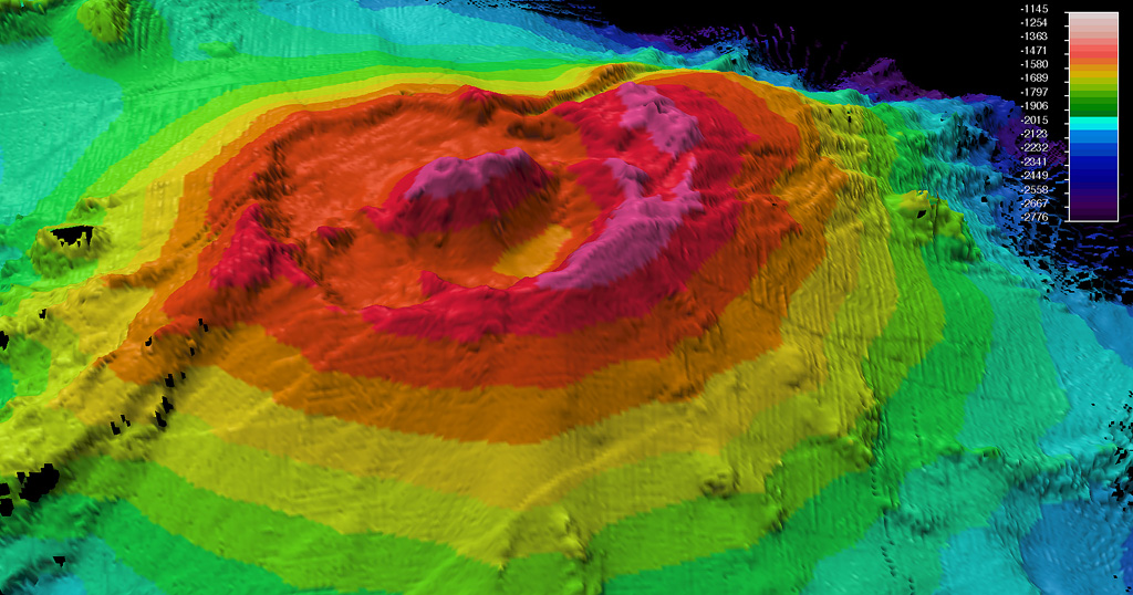
Rumble II West, about 12 km NW of Rumble II East, rises 1,800 m from the ocean floor to within 1,200 m of the surface. Bathymetry shows a 2.5-3 km summit caldera about 200 m deep with a central cone. There is evidence of hydrothermal activity, and cones are present on the flanks. Some lava flows on the western flanks originating from near the caldera rim have little or no sediment cover.
Storia delle eruzioni
Cronologia dettagliata
Nessuna registrazione di eruzioni disponibile.
Link esterni
- Non ancora su Wikipedia (Italiano). Puoi contribuire su Wikidata.
- 🔗 Pagina originale Smithsonian GVP
⚠ Solo a scopo informativo. Non adatto a situazioni di emergenza.