ハイリ・グッビ山
Hayli Gubbi
楯状火山 · Ethiopia · 493m
- タイプ
- 楯状火山
- 国
- Ethiopia
- 地域
- 東アフリカ / Afar Rift Volcanic Province
- 標高
- 493m
- 座標
- 13.511, 40.716
- 最終噴火
- 2025年
- テクトニクス環境
- Rift zone / Intermediate crust (15-25 km)
- 火山地形
- Shield
- 主要岩石
- Basalt / Picro-Basalt
地質学的概要
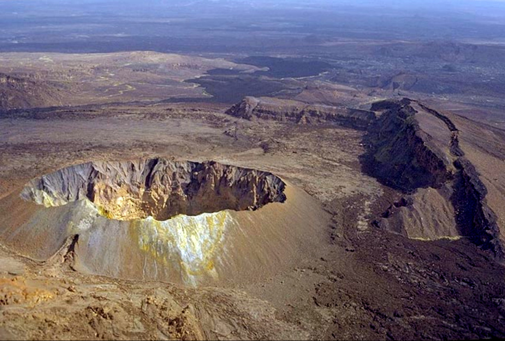
Hayli Gubbi is the southernmost volcano of the Erta Ale Range. Recent tectonism has created a NW-SE graben across the summit, with a 380-m-diameter scoria cone at the summit and a 260-m-diameter crater displaying fumarolic activity. A sequence of fissure vents and lava fields extends 6 km NW to the southern caldera of Erta Ale. Additional dark flows that originated from the summit area cover the W and NE flanks, and SE before turning E at the base on the shield. More fissure vents extend ~3.5 km SSE within the graben to another small shield. From there, the line of vents continues, along with a lava field that spreads across the Afrera Plain, to a distance of 25 km from the summit crater. Barberi and Varet (1970) reported that those basaltic flow fronts covered sediments in the plain which Roubet et al. (1969) described as lacustrine limestones and diatomites deposited around 8,200 years BP above hyaloclastite formations. This places the eruption of the SE-most flows sometime within the last 8,000 years, but no additional information about how recent they might be is known; in appearance they are similar to very recent flows from the Erta Ale shield. On 15 July 2025 a dike intrusion that originated at the Erta Ale N caldera pit craters produced active fissure vents and lava flows within and on the S flanks of the south caldera; another set of fissure vents were active 4 km SE from the caldera rim, within 2 km of the Hayli Gubbi crater. A large explosive eruption on 23 November 2025 excavated the previous summit cone and created a second large crater (~200 m in diameter) in the summit area, and a third smaller crater.
Wikipedia の要約
ハイリ・グッビ山またはヘイリ・ガビ山 は、エチオピアのアファール州にある楯状火山で、エルタ・アレ山脈の最南端に位置する。この地域が僻地であることから記録が限られているという面はあるが、完新世以来、2025年11月に至るまで12,000年に渡って噴火活動は記録されていなかった。
Wikipedia · CC BY-SA · 記事全文を読む →
噴火履歴
詳細タイムライン
- 2025年VEI ?観測記録2025-11-23 ~ 2025-11-23
- 紀元前 6250年VEI ?地質学的推定BCE 6250 ~ 進行中S flank
外部リンク
⚠ 参考情報です。緊急対応には使用しないでください。