バリアー山
Barrier, The
楯状火山 · Kenya · 1032m
- タイプ
- 楯状火山
- 国
- Kenya
- 地域
- 東アフリカ / Kenyan Rift Volcanic Province
- 標高
- 1032m
- 座標
- 2.320, 36.570
- 最終噴火
- 1921年
- テクトニクス環境
- Rift zone / Continental crust (> 25 km)
- 火山地形
- Shield
- 主要岩石
- Trachyte / Trachydacite
地質学的概要
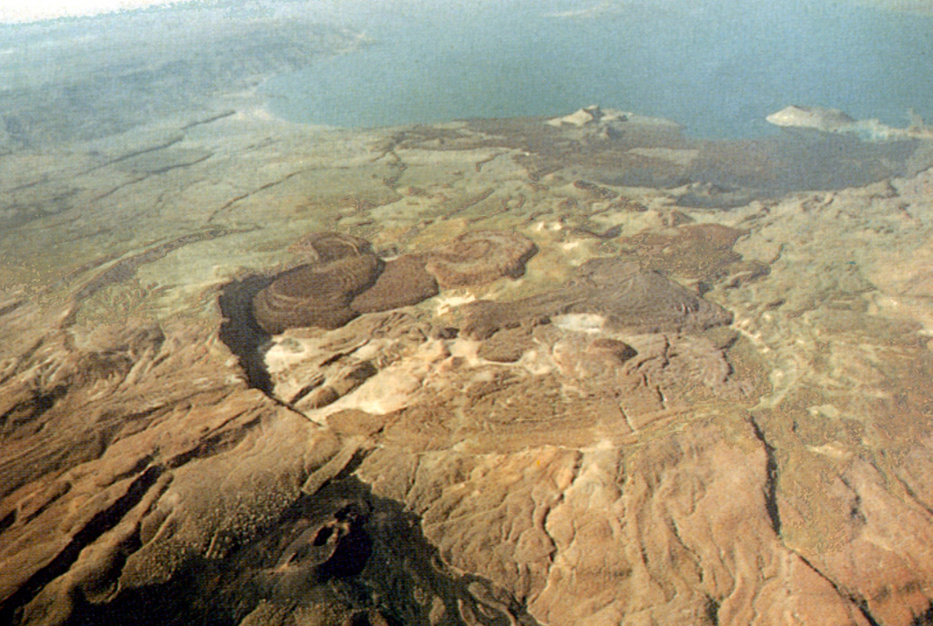
The Barrier volcanic complex separates Lake Turkana from the broad Suguta Trough to the S, the site of a former lake. The volcano is comprised of four overlapping shield volcanoes, with the youngest, Kakorinya, located over the axis of the East African Rift. Kalolenyang volcano lies W of Kakorinya, and Likaiu West and Likaiu East are located to the ENE. A 3.8-km-wide summit caldera was formed at Kakorinya about 92,000 years ago. Youthful-looking trachytic and phonolitic lava domes and flows erupted within the caldera and along its ring fracture fill much of the caldera floor. Early Holocene fissure-related scoria cones and lava flows dot the S and N flanks. Solfataric fields are located within the caldera and on the W and S flanks. Historical eruptions from Teleki's and Andrew's cones on the N and S flanks, respectively, have produced basaltic explosive activity and lava flows during the 19th and 20th centuries.
Wikipedia の要約
英語版の要約The Barrier is an active shield volcano located in the north of Kenya. It is last known to have erupted in 1921.
Wikipedia · CC BY-SA · 記事全文を読む →
噴火履歴
詳細タイムライン
- 1921年VEI 2観測記録1921-12-31 ~ 進行中North flank (Teleki)
- 1920年 (±3年)VEI ?地質学的推定1920-07-02 ~ 進行中South flank (Andrew's Volcano)
- 1917年VEI 2観測記録1917-07-02 ~ 進行中Andrew's or Teleki's Volcanoes
- 1906年VEI ?地質学的推定1906-07-02 ~ 進行中Andrew's or Teleki's Cones
- 1897年VEI 2観測記録1897-05-16 ~ 進行中North flank (Teleki) and Likaiu
- 1895年VEI 2観測記録1895-07-02 ~ 進行中North flank (Teleki's Cone)
- 1888年VEI 0観測記録1888-07-02 ~ 進行中North flank (Teleki's Cone)
- 1871年 (±3年)VEI 2観測記録1871-07-02 ~ 進行中North flank (Teleki's Cone)
- 1090年 (±50年)VEI 0地質学的推定1090 ~ 進行中North flank
- 1050年 (±150年)VEI 0地質学的推定1050 ~ 進行中North flank
- 1030年 (±150年)VEI 0地質学的推定1030 ~ 進行中North flank
- 紀元前 7710年 (±200年)VEI ?地質学的推定BCE 7710 ~ 進行中North (Abili Agituk) and south flanks
外部リンク
⚠ 参考情報です。緊急対応には使用しないでください。