本文へスキップ
地図に戻る
比較

ワイ・サーノ山

Sano, Wai

カルデラ · Indonesia · 1319m

Wai Sano, the westernmost Holocene volcano on Flores Island, contains a 3.5 x 2.5 km caldera with a lake. The SE caldera wall truncated the slopes of Poco Sesak (also called Gunung Cerak), and the low point on the caldera rim is on the E side. Two solfataras are located at the SE shore of the lake.
Wai Sano, the westernmost Holocene volcano on Flores Island, contains a 3.5 x 2.5 km caldera with a lake. The SE caldera wall truncated the slopes of Poco Sesak (also called Gunung Cerak), and the low point on the caldera rim is on the E side. Two solfataras are located at the SE shore of the lake. · 写真: Photo published in Kemmerling 1929, "Vulkanen van Flores" (courtesy of Volcanological Survey of Indonesia).
タイプ
カルデラ
Indonesia
地域
Sunda-Banda Volcanic Regions / Sunda Volcanic Arc
標高
1319m
座標
-8.735, 120.007
最終噴火
不明
テクトニクス環境
Subduction zone / Continental crust (> 25 km)
火山地形
Composite
主要岩石
Dacite
地質学的概要

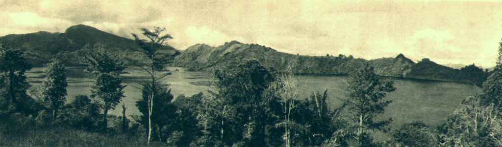
The Wai Sano composite volcano at the western end of Flores Island includes a 2.5 x 3.5 km elliptical caldera in the NW part of a larger 9-10 km edifice. The caldera contains Sanonggoang Lake, with a surface more than 200 m below the high point on the southern caldera rim. The Poco Sesok and Poco Dedeng peaks are near the center of the eroded massif. The area has been a target of geothermal investigations, and two solfataras are located at the SE shore of the lake. No eruptions have been reported or dated, but the area was mapped as Holocene (Ratman and Yasin, 1978).

Wikipedia の要約

英語版の要約

Wai Sano is a volcano located in the western part of the island of Flores, Indonesia. Wai Sano consists of an elliptical caldera about one mile (2.5 km) wide, containing a lake 260 meters below the 903 meter caldera rim, itself part of Mount Umpu Rua. Two fumaroles are located on the southeastern shore of the lake. No historical eruptions are known.

Wikipedia · CC BY-SA · 記事全文を読む

噴火履歴

詳細タイムライン

噴火記録はありません。

外部リンク

⚠ 参考情報です。緊急対応には使用しないでください。