モンタギュー島
Montagu Island
楯状火山 · United Kingdom · 1370m
- タイプ
- 楯状火山
- 国
- United Kingdom
- 地域
- 南極・スコシア / South Sandwich Volcanic Arc
- 標高
- 1370m
- 座標
- -58.445, -26.374
- 最終噴火
- 2007年
- テクトニクス環境
- Subduction zone / Oceanic crust (< 15 km)
- 火山地形
- Shield
- 主要岩石
- Basalt / Picro-Basalt
地質学的概要
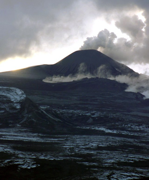
The largest of the South Sandwich Islands, Montagu consists of a massive shield volcano cut by a 6-km-wide ice-filled summit caldera. The summit of the 11 x 15 km island rises about 3,000 m from the sea floor between Bristol and Saunders Islands. Around 90% of the island is ice-covered; glaciers extending to the sea typically form vertical ice cliffs. The name Mount Belinda has been applied both to the high point at the southern end of the summit caldera and to the young central cone. Mount Oceanite, an isolated peak at the SE tip of the island, was the source of lava flows exposed at Mathias Point and Allen Point. There was no record of Holocene activity until MODIS satellite data, beginning in late 2001, revealed thermal anomalies consistent with lava lake activity. Apparent plumes and single anomalous pixels were observed intermittently on AVHRR images from March 1995 to February 1998, possibly indicating earlier volcanic activity.
Wikipedia の要約
モンタギュー島 は、サウスサンドウィッチ諸島の島で、同諸島最大の島である。イギリス領サウスジョージア・サウスサンドウィッチ諸島に属している。無人島。最高点は1,370 m(ベリンダ山)。2001年から2007年にかけて噴火した。
Wikipedia · CC BY-SA · 記事全文を読む →
噴火履歴
詳細タイムライン
- 2001年VEI 1観測記録2001-10-01 ~ 2007-09-20NW of Mount Belinda
- 1996年VEI 1地質学的推定1996-09-01 ~ 進行中
外部リンク
⚠ 参考情報です。緊急対応には使用しないでください。