하일리구비산
Hayli Gubbi
순상화산 · Ethiopia · 493m
- 화산 유형
- 순상화산
- 국가
- Ethiopia
- 지역
- 동아프리카 / Afar Rift Volcanic Province
- 해발
- 493m
- 좌표
- 13.511, 40.716
- 마지막 분화
- 2025년
- 판구조 환경
- Rift zone / Intermediate crust (15-25 km)
- 화산 지형
- Shield
- 주요 암석
- Basalt / Picro-Basalt
지질학적 요약
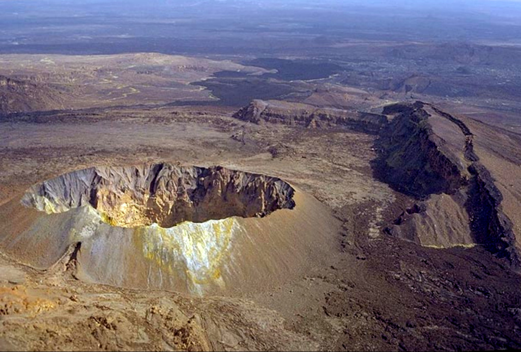
Hayli Gubbi is the southernmost volcano of the Erta Ale Range. Recent tectonism has created a NW-SE graben across the summit, with a 380-m-diameter scoria cone at the summit and a 260-m-diameter crater displaying fumarolic activity. A sequence of fissure vents and lava fields extends 6 km NW to the southern caldera of Erta Ale. Additional dark flows that originated from the summit area cover the W and NE flanks, and SE before turning E at the base on the shield. More fissure vents extend ~3.5 km SSE within the graben to another small shield. From there, the line of vents continues, along with a lava field that spreads across the Afrera Plain, to a distance of 25 km from the summit crater. Barberi and Varet (1970) reported that those basaltic flow fronts covered sediments in the plain which Roubet et al. (1969) described as lacustrine limestones and diatomites deposited around 8,200 years BP above hyaloclastite formations. This places the eruption of the SE-most flows sometime within the last 8,000 years, but no additional information about how recent they might be is known; in appearance they are similar to very recent flows from the Erta Ale shield. On 15 July 2025 a dike intrusion that originated at the Erta Ale N caldera pit craters produced active fissure vents and lava flows within and on the S flanks of the south caldera; another set of fissure vents were active 4 km SE from the caldera rim, within 2 km of the Hayli Gubbi crater. A large explosive eruption on 23 November 2025 excavated the previous summit cone and created a second large crater (~200 m in diameter) in the summit area, and a third smaller crater.
Wikipedia 요약
하일리 구비 산(암하라어: ሃይሊ-ጉቢ Haylē-Gubi)는 에티오피아의 아파르주에 위치한 순상 화산이다. 에르타 알레 산맥의 가장 남쪽에 있는 화산이다. 2025년 11월까지 홀로세 시대가 시작된 이래 지난 12,000년 동안 이 화산의 분화 기록은 알려지지 않았다. 해당 지역의 분화 기록은 지역의 외딴 지리적 특성 때문에 제한적이다.
Wikipedia · CC BY-SA · 전체 기사 보기 →
분화 이력
상세 타임라인
- 2025년VEI ?관측 기록2025-11-23 ~ 2025-11-23
- 기원전 6250년VEI ?지질학적 추정BCE 6250 ~ 진행 중S flank
외부 링크
⚠ 참고용 정보입니다. 재난 대응에 사용하지 마세요.