본문으로 건너뛰기

McDonald Island

McDonald Islands

복합화산 · Australia · 263m

Three small, low islands on the Kerguelen Plateau form the McDonald Islands. The largest island, McDonald, is only 1 km2 in area and around 200 m high. This April 1997 photo shows a plume at Samarang Hill (right). The Island is composed of a layered tuff plateau cut by dikes and lava domes. A possible nearby active submarine center was inferred from pumice that washed up on Heard Island in 1992. The snow-capped peak in the background is Heard volcano, 44 km to the E.
Three small, low islands on the Kerguelen Plateau form the McDonald Islands. The largest island, McDonald, is only 1 km2 in area and around 200 m high. This April 1997 photo shows a plume at Samarang Hill (right). The Island is composed of a layered tuff plateau cut by dikes and lava domes. A possible nearby active submarine center was inferred from pumice that washed up on Heard Island in 1992. The snow-capped peak in the background is Heard volcano, 44 km to the E. · 사진: Copyrighted photo by Richard Williams, 1997 (Australian Antarctic Div., published in Global Volcanism Network Bulletin).
화산 유형
복합화산
국가
Australia
지역
Somalian-Antarctic Volcanic Regions / Kerguelen Hotspot Volcano Group
해발
263m
좌표
-53.039, 72.595
마지막 분화
2005년
판구조 환경
Intraplate / Oceanic crust (< 15 km)
화산 지형
Composite
주요 암석
Phonolite
지질학적 요약

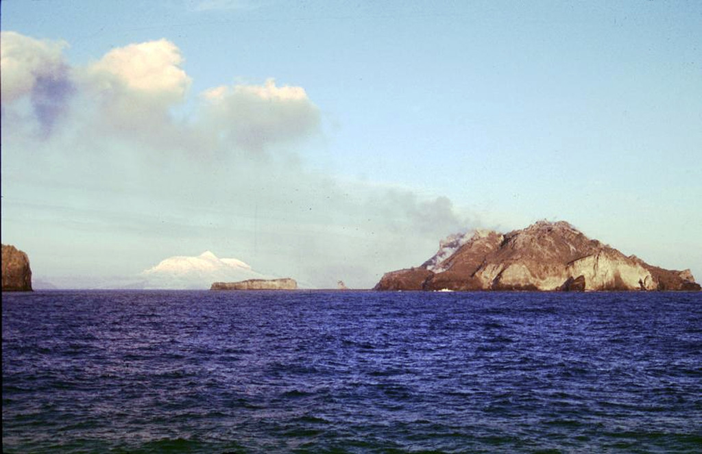
The McDonald Islands are located on the Kerguelen Plateau about 75 km W of Heard Island. The largest island, McDonald, is composed of a layered phonolitic tuff plateau cut by phonolitic dikes and lava domes. A possible nearby active submarine center was inferred from phonolitic pumice that washed up on Heard Island in 1992. Volcanic plumes were observed in December 1996 and January 1997 from McDonald Island. During March 1997 the crew of a vessel that sailed near the island noted vigorous steaming from a vent on the N side of the island along with possible pyroclastic deposits and lava flows. A satellite image taken in November 2001 showed the island to have more than doubled in area since previous reported observations in November 2000.

Wikipedia 요약

영어 요약

The McDonald Islands are an uninhabited archipelago in the southern Indian Ocean in the vicinity of Heard Island. Together with Heard Island, they make up the Australian external territory of Heard Island and McDonald Islands. The McDonald Islands are the emergent peaks of submarine volcanoes and are Australian external territory. Prior to 1992, there had not been an eruption in the previous 75,000 years.

Wikipedia · CC BY-SA · 전체 기사 보기

분화 이력

요약 (VEI 시계열)
막대를 클릭하면 개별 분화가 표시됩니다
1992~1993 · 1건 · 최고 VEI 01996~1997 · 1건 · 최고 VEI 12000~2001 · 1건 · 최고 VEI 12004~2005 · 2건 · 최고 VEI 119921995199920012004

상세 타임라인

  1. 2005년VEI 0관측 기록
    2005-07-12 ~ 진행 중
  2. 2004년VEI 1지질학적 추정
    2004-11-14 ~ 2004-11-14
  3. 2001년VEI 1관측 기록
    2001-05-03 ~ 진행 중
  4. 1996년VEI 1관측 기록
    1996-12-16 ~ 1997-02-10
    Northern part of McDonald Island
  5. 1992년VEI 0관측 기록
    1992-12-16 ~ 진행 중
    Submarine vent near McDonald Islands

외부 링크

⚠ 참고용 정보입니다. 재난 대응에 사용하지 마세요.